Monday, December 28, 2015

Gordon Pond Hike


A few days after Christmas, Jimmy, Christine, Jacqueline and I headed up to do some hiking. We had hoped to snowshoe, but the weather didn't cooperate and instead we had a very icy, very cold day (temperature in the low teens). We picked a trail near Woodstock off of 112 and hoped to get to Gordon pond, which is about 3 miles each way.

The trail was pretty much all iced over, so we all used microspikes the whole way. Camelbacks froze quickly despite our efforts to keep water out of the tubes.

(sweet inside-out hat)


Jacqueline broke through some ice and went knee deep in water almost right away. She was a trooper and kept going despite the wet foot. Video of her frozen pant leg here:


The gang was pretty cold, so we turned back before the pond and headed back for the car. It was a pretty day in the woods.


We caught a late afternoon showing of Star Wars and then headed back to the Woodstock Inn for beer and too much food. Good times had by all.

Pictures here: Jimmy's SLR and some iPhone

Friday, December 4, 2015

Zealand Falls Hut


This one started as a pretty ambitious plan. Starting Thursday, I was going to drop my bike at the Zealand Road Trailhead (around mile marker 13 on the map below). I was then going to drive back to the Haystack Road Trailhead (mile marker 0), and hike from the car  to the Zealand Falls Hut (mile marker 11.5). On Friday, I would wake up and head to my bike and then ride the roads back to the car. This would bag me both North and South Twin Mountain, as well as Mount Zealand.


A couple things didn't work out. First, the weather. It was supposed to snow 1-3" on the ridgeline, but just be a dusting at lower altitudes. Second, it had been raining for several days before I got there leading to very high river and stream flooding. More on that later.

I left Boston at 4:30 AM on Thursday to make the most out of the late season daylight. When I got to Bethlehem, a little after 7:00 it was 38 degrees and misting rain. Pretty gross for hiking. I ditched my bike at the Zealand Road Trailhead under a tree and drove about 25 minutes back to the Haystack Road Trailhead. As I geared up, the temperature had dropped to the low 30s and I saw a few snowflakes among the rain.

Under the tree cover, the rain and snow were mostly blocked and I made very good time heading up toward the peak of North Twin. There were several higher than normal stream crossings, but nothing too troubling, and I stayed dry.

About 2 miles in, I got to a river crossing that was completely washed out. There was no where to go across without getting waist deep in fast running water. I bushwhacked off trail following the river for about half a mile, but it was all the same. There were a few places where I could get pretty close to making in across, but each one had at least one place where I was going to be very wet in fast running water. The mixed rain had turned to all snow, and I decided it wasn't worth chancing and made my way back to the car.


By the time I got back to the car, the snow was covering the road. As mentioned earlier, it wasn't supposed to snow this much down low. I decided that I wanted a plan that had multiple options to shorten or bail entirely given the conditions. Zealand was appealing because I could approach from the side of the trail with the hut, drop my pack at the hut, and continue on only if the conditions were good.

When I got back to Zealand Road, (between 16-17 on the map above) the road was already at least an inch deep in snow. I had spoken to the AMC the day before the trip and knew that they might close the road if it snowed. I did not want to chance driving 4 miles up to the trailhead only to have them close the gate and trap my car inside, so I parked on 302 and decided to walk the road. That meant my bike was stuck at the trailhead, but that was a problem for another day.

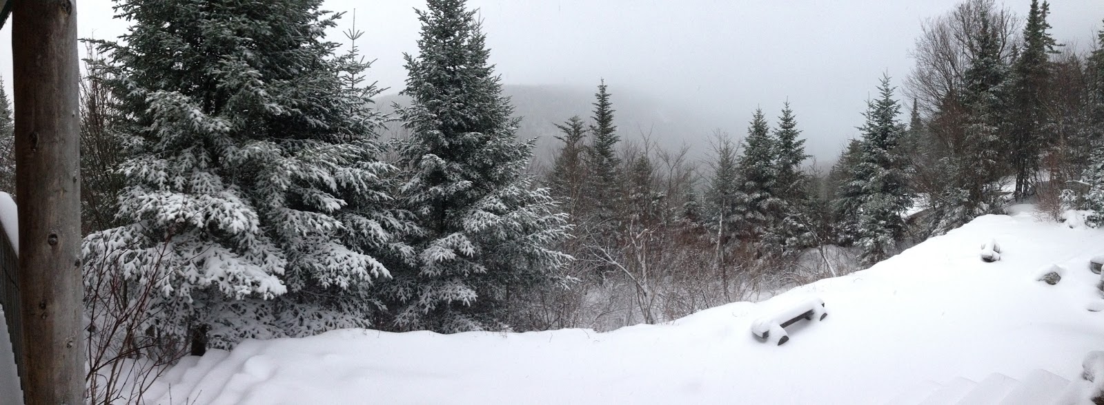
The road walk was about 90 minutes, but really cool with the trees already bowing over with snow. On approach to the hut, the wind had really picked up and was blowing the snow around. I could no longer see the peak of Zealand, and my boots had completely soaked through. It was only 2PM, but I was decided to call it a day when I reached the hut.


Like the other AMC huts, Zealand Falls Hut is unheated in the winter, but provides a gas stove in the kitchen, and dry bunks. I was the only one at the hut when I arrived, so I warmed up in my sleeping bag, read my book, and napped through the afternoon. Around 4:00, the caretaker arrived and fired up the woodstove. I spent the evening with about 9 other hikers who were passing through. We traded beers for bourbon and swapped hiking plans and ideas. A couple of guys were going to hike out really early, so I agreed to join them for the first half mile or so.


There is zero cell service in this part of the White Mountains, and I felt guilty about not being able to check-in. Getting out early sounded like a good idea. We were on the trail around 5 AM on Saturday. It had snowed over 6 inches at the hut and was still coming down a little when we set out. We trekked down with spikes on and headlamps lighting the way. I said goodbye at the trail split and made my way down to my bike alone. I was back to the trailhead well before the sun had come up, and now had to deal with my bike.


It was completely frozen when I pulled it from under the tree to the point that the wheels wouldn't even rotate. I got it on the road with the plan to just walk it back to the car. After a few minutes, the wheels were turning, so I did some gentle gliding. It definitely was not built for the snow, and I'm pretty sure most bikes aren't. I rode the bike like one of those toddler bikes with no pedals, and had my feet dragging on the ground the whole time. It took a long time (1 hr for <4 miles) but I made it back to the car without incident.


I ended up bagging 0 of the 3 intended peaks, but given the weather and being solo, I had no regrets. It was a really fun couple of days and I hope to get back to that section soon in better weather.

Pictures: here


Sunday, November 8, 2015

Carter Middle (4,610'), Carter South (4,430'), Mt. Hight (4,675' - not official 4K list), Carter Dome (4,832'), and Wildcat A (4,422')


Steve and I met on Saturday morning near Wildcat on 16 and dropped cars at both Nineteen Mile Brook and the Imp trailheads. We had a reservation at the Carter Notch Hut and the plan was to hit four 4Ks on Saturday, crash at the hut, and then hike out on Sunday.

It was pretty warm at the base and very windy. There were a surprising amount of cars in the parking lot for this late in the season. We took the Imp trail which is very gradual, and then turned onto the North Carter trail which climbed more steeply to the Carter ridge. The ridge is mostly under tree cover but occasionally had impressive views of Washington in the clouds and a clear view into Maine to the east. The wind was strong but not overpowering and the temperature had dropped into the high 30's on the ridge. 

We hit Middle and South Carter and descended to Zeta Pass. We had to decide whether to head to Mount Hight which is over 4,000 feet but not an official 4K, or to bypass Hight and keep going for Carter Dome. We were losing daylight, but decided to go for it anyway since we had heard it had great views. It turned out to be a great decision. Mount Hight has 360 degree views of the White Mountains and the wilderness area to the east. Its probably the best overall view I've seen in the White Mountains to date. 

From there, we hit Carter Dome, the 4th summit of the day and the 3rd from the official list. It was around 3:45 when we got there and we realized we had no shot of making it to the Hut and getting up Wildcat before dark. The Carter Dome summit is at 4,800 feet and the hut is down all the way to 3,200 feet with only a mile of trail between them. Its a pretty steep downward climb. At various points on the trail we could see the Hut way down in the Notch below, and we could see Wildcat A rising very steeply to the south of the Notch. At the time, climbing Wildcat A seemed like it was a climb going straight up a cliff. 

We arrived at the "Hut" just before sunset. Its really more of a compound with a main building with a woodstove and kitchen and separate bunkhouses. It sleeps 40 people and there were 28 people on Saturday night. We signed up for a dinner slot (for access to the kitchen) and played some cards and drank some bourbon. We ate a big dinner before crashing early. The bunk house was very comfortable. Its unheated but provided mattresses, pillows, and good wind protection. 

It snowed an inch or so overnight and we got up early to snag Wildcat A. It looked a lot more manageable after a night of sleeping. The trail was snow covered but not treacherous. I opted for microspikes for some extra stability, but Steve bare-booted with no issues. There's a great overlook near the Wildcat summit looking east toward Maine over Sebago lake. We made good time up and down without our packs. We backtracked to the hut and grabbed our packs and then hiked the 4 miles back to the car. 

All-in, the trip was just under 15 miles with about 5,700 feet of elevation gain.

iPhone and Steve's SLR pictures: here

Saturday, October 10, 2015

Mount Hale (4,054')


Jacqueline and I headed up North pretty late (left Newton a little after 9). The plan was to hike Mount Hale and potentially camp on Saturday night. The leafers were out in force this weekend with sections of stop and go traffic even north of Concord.

Once we got north of Franconia Notch, the crowds thinned and the drive was beautiful. There was snow on the taller peaks and especially on Washington. It was a cool contrast with the colorful leaves down low and the snow up high.

We started up the trail a little after noon. It is a gradual climb for the first mile or so. There were a few pretty stream crossings and some views through the trees of Washington and other nearby peaks. The last half mile is steeper and rockier, but nothing too difficult. The summit is in a clearing with some grassy patches, but no views to speak of. It was a great place to sit and have lunch.

Round trip it was 4.4 miles and we finished it right around book time of 3 hours, 30 minutes. The temperature was in the 40's and we both agreed that camping didn't sound the best, especially because Jacqueline was fighting a cold. She was a trooper.

We grabbed dinner and beers at the Woodstock Inn on the way back home. We used our camp fire wood in the fireplace and watched a bad movie. It was a good day in the woods. One more down.

20 to go.

Combo of SLR and iPhone pictures here: Pictures

Saturday, October 3, 2015

Mount Tripyramid North (4,180), Mount Tripyramid Middle (4,140), Mount Tripyramid South (not official 4K)


The ambitious plan was to hike four of the 4K's in one big loop. We would get all three Tripyramids (two official 4Ks) from the Kanc via the Pine Bend Brook trail, and then cut over to Whiteface and Passaconaway on the Kate Sleeper trail and descend to the Oliverian Brook trailhead (trail map included below for reference). We dropped cars at each trailhead and started up to North Tripyramid around 8:30. The trip was to be 16 miles, 6,000 ft of gain, and with a book time of approx 12 hours. We figured we could outpace the book time, but were keeping an eye on the clock to avoid descending in the dark. We planned to bailout on Downes Brook about halfway down Kate Sleeper) if we were behind schedule.

The trail was very gradual for the first couple miles but then steeply ascended to North Tripyramid. We made very good time, and kept pushing to Middle and South Tripyramid. All three peaks are over 4,000 feet, but the South peak is not an official 4,000 footer (inadequate col). When we arrived at the south peak, we were 2 hours ahead of book time. Well ahead of schedule to keep going and get all 4 peaks. 

After the south peak, the Mt. Tripyramid trail descends very steeply down the south side of the mountain. We stopped for lunch on an overlook and then began down the steep trail. Somewhere along the way, perhaps distracted by the steep descent, we missed the left turn for the Kate Sleeper trail. By the time we were sure we had missed it, we had gone a mile too far and descended almost 1,400 vertical feet. There was no way we were going to backtrack up the steep trail and have enough time and energy to complete the full hike before dark. 


Unfortunately we didn't have a lot of good options for getting back to the car because we were on the wrong side of the mountain. We pulled out the maps and figured out a roundabout way back by continuing down to the bottom of Mt Tripyramid, wrapping around the base of the mountain on Livermore road, and then climbing up the Scaur Ridge trail, and then back down Pine Bend Brook. The frustrating part of this route is that it was be almost exactly as long and challenging as our original planned route, and with 2 fewer peaks off the list. Oh well. Beautiful day and good hike. Distance was just over 16 miles with 5,500 of elevation gain.

Given the amount of leafers up north, I was a little worried about getting a camp site. I guess not a lot of people want to go camping when the temp drops to the low 30's overnight. Their loss.We set up camp at Hancock and grabbed dinner and beers at the Woodstock Inn. Made a big camp fire and crashed hard. Home in time for football on the couch all day Sunday.


Sunday, May 10, 2015

Mount Osceola (4,340'), Mount Osceola East (4,156') (Climb#2)


Steve and I worked on the boat in Danvers all day on Saturday and then headed up to Hancock campground in the evening. Cooked some hot dogs on the campfire and crashed pretty early.

On Sunday morning we hiked the Osceolas from the Kanc. We intended to do a traverse to Tripoli, but we found the road still closed when we went to drop the car there. Barebooted the first half and microspikes the rest of the way. No snowshoes needed.

Pictures here: iPhone Pics Steve's DSLR Pics